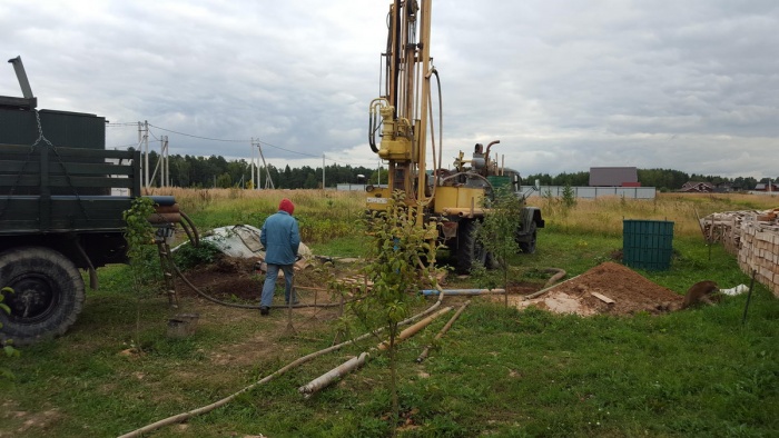
The most important parameter of a water well is its depth. This indicator directly affects the level of water quality and prices for drilling operations. The price list of companies providing such services is focused on the depth level, and site owners do not want to pay for non-existent meters. In cases where the well is developed on its own, knowing the exact depth helps to choose the optimal pump for pumping out water.
The depth level of a hydraulic structure is influenced by how aquifers are located in a given area. The function that the extracted water will perform is also of great importance. To water your garden and vegetable garden, you can take the liquid from the top groundwater: they can be located at a distance of 4-6 m from the ground surface. The horizons suitable for drinking are an order of magnitude deeper (from 15 m).
Types of wells depending on their depth
There are three main types of wells:
- Abyssinian (8-12 m). The simplest hydraulic structure, suitable for independent arrangement in a country house or country house. The mine is included in the first aquifer, and is usually used for irrigation and technical purposes. If you use a filter system, you can also use this water to meet your household needs.
- Sandy (15-30 m). Average level well flow rate for sand is 1 m³/h, which allows providing water Vacation home or a medium sized cottage. This water can be drunk, but the source will need to be periodically cleaned to remove siltation.
- Artesian (70-100 m). The high quality of the liquid extracted in this way is explained by the presence of multi-layer natural filtration. The flow rate is also pleasing - from 3 m 3 / h. Artesian water is in great demand in medical field due to the presence of useful minerals in its composition. The invested funds are fully repaid by the longevity of the artesian source: it usually lasts for at least 60 years.
Professionals invited to work, as a rule, already have data from past geological exploration, and can provide information in advance about the approximate depth of the future well. With self-drilling, these parameters can be obtained only after reaching the aquifer. To do this, several methods of varying degrees of complexity are used.
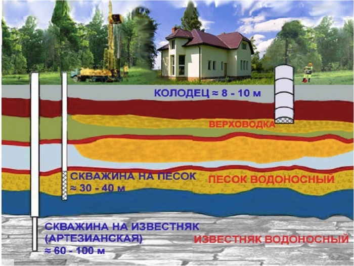
It is also important to take into account the fact that several aquifers may lie in one area at different depths:
- Verkhovodka. The layer closest to the surface of the earth, lying at a depth of 3.5-4 m. It is replenished by melting snow and rain, which explains the presence of a large amount of dirt in the water. All these impurities end up in the water as it percolates through the soil. The short distance does not allow it to be filtered. Verkhodok are characterized by large changes in volume: after atmospheric precipitation the level increases sharply, and during dry periods it may disappear altogether. Wells fed from perched water are used exclusively for technical purposes.
- Groundwater. They lie at a depth of about 10 m. A layer of this type demonstrates greater stability compared to perched water, not drying out in frosty or dry weather. The quality of groundwater is also an order of magnitude higher, which allows it to be used both for technical purposes and for cooking.
- Interstratal waters. They are located at a distance of 10-100 m from the surface of the earth. They are a kind of interlayer, separating two water-resistant layers. Most often, drinking wells are installed on this layer. This is explained high quality water and comparatively cheap (compared to the artesian layer).
- Artesian waters. Usually they lie at a distance of 100 m or less from the surface. Although there are exceptions: in some areas artesian water can be found at a depth of 50 meters. Waters from the artesian layer have the most high degree cleanliness.

Aquifers
There are several ways to find out the approximate depth of a well before drilling:
- Survey of neighbors in the area. If your neighbors use a well or well, you can always get this information from them. It’s even better if there is technical documentation for the well: it usually indicates not only the depth, but also the flow rate.
- Study geological research data. Such a plan is the result of engineering and reconnaissance activities carried out in the area. It contains information about the specifics of the soil and the pattern of aquifers. Having such documentation in hand, drilling a well is much easier.

Upon completion of the work, the drilling company must provide a technical passport for the finished well with its parameters. The depth of the mine is also indicated there, but some users doubt the reliability of this data.

Sample technical passport for a well
We can immediately say that serious organizations never engage in providing false indicators in order to obtain additional benefits. Therefore, in order not to worry about the result, it is better to do business with companies that have a good reputation. They will always offer customers who are too distrustful to be present during drilling. You can verify the accuracy of the information personally by counting the rods used by the drilling rig.
As for suspicious advertisements promising the construction of a well at a cheap price, it is recommended to ignore them.
This is the easiest way to determine the depth of a well or shallow well. It is implemented using a construction tape measure, a cord and a steel weight. Clear, dry weather is best for taking measurements in this way. Optimal timing– end of summer, beginning of autumn. The fact is that during this period groundwater is at its lowest level.

Tools for self-measurement well depth
Operating procedure:
- Determine the diameter of the well. A ruler is used for this. This will make it possible to select a suitable load.
- Lower the string with a weight at the end inside the shaft until the cord reduces its tension. This indicates contact with the bottom of the well.
- Pull the string out and lay it out in a straight line on the ground. By measuring the dry part, determine the distance to the water surface. To simplify the task, before starting the procedure, the cord is equipped with colored ribbons at the same distance.
- The size of the wet section of the string will indicate the volume of the source well.

Measuring the depth of the well using string and sinker
The main disadvantage of this simple method is the significant limitations on the measured depth (no more than 10 m).
In addition, the dimensions of the wet area indicate only the static level of the well, while when installing a pump it is necessary to know the dynamic level. To determine it, a suction hose with a filter at the end is threaded inside the casing: it must reach the bottom. Turning on the pump, time the time until the water supply is completely emptied. You need to turn off the pump only after specific squelching sounds appear. After this, the depth measurement procedure is repeated again: the height of the remaining water is the dynamic level.

This tool (abbreviated as RGLM) allows you to measure wells with a depth of 10-50 m. Limitations on the diameter of the casing pipe are at least 20 mm. A hydraulic tape measure consists of a body, a reel with a speed regulator, a measuring tape and a weight with a clapper.

Instructions for using RGLM are very simple:
- Insert a tape with a weight into the pipe. The load must be lowered gradually, for which there is a special regulator with a brake.
- A strong pop will be a signal that the water has been reached.
- After the clap, the tape measure is immediately stopped and readings are taken on the scale. They will indicate the level of the aquifer.

Measuring the depth of the well with a hydrogeological tape measure
The operation of the IUGS device is based on the principle of a reflected echo signal sent by a special emitter. After reflection from the bottom, the data is processed internally. In this way, depths of up to 80 m can be determined with an accuracy of 150 mm. The recommended casing diameter is from 60 to 150 mm.

Measuring the depth of the well with a depth gauge
The IUGS depth gauge consists of an electronic unit, an acoustic probe and an angular adapter. The latter device allows you to determine whether there are deviations from vertical line. It is very convenient that a battery is used for power: this makes it possible to carry out work away from power lines.

Acoustic depth gauges are also very popular in the mining industry. The only drawback of devices of this type is their high cost. Purchasing such a device for domestic use is not very profitable. More practical option– rent a depth gauge.
This depth determination device is mechanical. To wind the logging cable, a reel with a measuring roller is used. It is calibrated so that there is 1 m of cable per turn. The number of revolutions of the coil indicates how deep the aquifer is. In order to carry out a visual inspection of the hydraulic structure, a portable video camera with a battery is attached to the end of the cable.

Sometimes the proposed accuracy of the logging cable is not enough. To correct the situation, the tape is equipped with magnetic marks applied at a certain pitch. A special device is used to read magnetic symbols. During operation, the cable gradually stretches, so it is recommended to update the magnetic markings from time to time.
A professional device, the principle of operation of which resembles the IUGS device discussed above.

In this case, instead of conventional sound waves, ultrasound is used for measurement. Its pulses are sent towards the obstacle, and by determining the difference between the time the signal is sent and returned, the final result is produced. Ultrasonic level meters allow you to determine the level of the medium without coming into direct contact with it. They are used to work in hard to reach places, which can include a well.
Results
The need to accurately determine the depth drinking well usually occurs in two cases. The first is when you need to check the work of the drilling company, because... The calculation for the work is carried out according to the depth of the depth. Such information will also be required when independent arrangement wells: it will help you decide on a pump. When choosing a measurement method, take into account the required level of accuracy and your financial capabilities.
Your own well allows you to use water regardless of the availability of a central water supply and its operating conditions. An important indicator when drilling is the depth of the well for drinking water. What it should be and how to determine the required parameter, we will consider in detail.
Water well depth: what it depends on
Before developing a well design and starting drilling operations, it is important to determine the depth. There are several criteria that determine the depth to which you will have to drill:
- Level of location of aquifers. Test drilling or area analysis taking into account the geological structure will help determine the indicator.
- Relief of the site. On a flat surface, the water may be located at a shallow depth; in a hilly area, it is recommended to drill in a lowland.
- Purpose of the well. The quality of water in the upper horizon does not always meet the standards established for the category of drinking water, so it will be necessary to drill to greater depths. If the source is intended exclusively for watering the site, you can build an Abyssinian well.
- Required well flow rate. In addition to quality, the volume of water received per unit of time is important to consumers. This parameter is the source performance, or debit. In Abyssinian wells the figure is 0.5 m 3 /h, in a sand well the volume increases to 1.5 m 3 /h, the artesian spring has the highest productivity, where the water flow reaches 3-4 m 3 /h.
The approximate cost of exploratory drilling of a water well is 400-600 rubles.

Drilling depth, how to determine
Before drilling a well, it is necessary to find out the structure of the aquifers. The figures vary even by small area, therefore, orientation to the neighboring area is not always justified. Since there are no instruments that accurately determine at what depth the water is located, the work is organized taking into account data from test drilling in a specific region.
One way to determine the water level is to analyze the vegetation of the area. Plants act as a kind of indicator of the presence of moisture.
Comment! Some aquifers require obtaining permits for development, and their operation is accompanied by taxation. A well with a depth of up to 5 m is not subject to registration and annual payment. An indicator over 15 m obliges the corresponding source to be registered.
According to the Law of the Russian Federation “On Subsoil”, it is possible to drill a well and use a source from the first aquifer without special registration. The sand well and the Abyssinian well fall under this category. Depending on the hydrogeology of the soil, in some regions the maximum depth without permitting documentation stops at 35 meters.
Core test drilling is considered to be the most reliable way to determine the depth of a water well. The appearance of moistened sand is a signal to stop drilling. A break is necessary to fill the channel with water. Then it is pumped out and the debit is determined. If the indicators are sufficient, they proceed to the arrangement of the source. If productivity is insufficient, continue drilling to the next aquifer.
The characteristics of the liquid depend on the layer from which it enters the water supply system. Not all water is suitable for drinking; to determine its composition, an examination is carried out in the laboratory after drilling. The horizon chosen for drilling subsequently determines the amount of water tax.

Aquifers
Before getting an answer to the burning question of how deep to drill a well, they understand the diversity and characteristics of aquifers. The layers that provide the supply of water for household needs are divided into 3 groups:
- The upper one is called perched water; its depth varies from 4 to 7 m. There is no stable water-resistant layer here, so water from the well is used mainly for irrigation and other technical needs. Liquid is often it's muddy, due to the presence of sand and other impurities.
- The second layer is located at a depth of 10 to 18 meters. Typically, drinking water comes into the well from this formation.
Note! After groundwater passes through the well filters, the water becomes much cleaner than that taken from a well. However, here too there is a risk of dangerous and harmful impurities. It especially increases during spring floods. Sometimes there is a smell of hydrogen sulfide. Water analysis for compliance with SES requirements, which is carried out by licensed laboratories, will help prevent poisoning.
- Artesian waters are located on the third aquifer. The depth of its occurrence varies at around 25-40 meters. However, the indicator depends on the topography of the area and sometimes reaches 60 m. Artesian water is considered the most healthy and clean.
A visual diagram of the occurrence of aquifers is shown in the photo:
Types of wells
Autonomous water sources are divided into three types:
- The use of perched water comes from the Abyssinian well.
- Drilling to the depth of groundwater allows you to equip a well for sand.
- The artesian source is characterized by its maximum depth.
The first type reaches a depth of 8-13 meters. Well water is used for domestic purposes, including cooking. A special feature of the design is protection against the ingress of water from the spring into the source.
The development of the source for sand is carried out using the auger drilling method. The depth is below the soil surface and is about 15-20 meters. The passage of water through the sand ensures its purity, allowing it to be used for drinking. The well can be operated periodically and year-round.
Water when drilling an artesian well is considered ideal in terms of purity. Private sources are equipped at a depth of 15 to 50 m; when used for production purposes, the drilling depth reaches 200 meters.
Comment! With regular maintenance, the service life of an artesian well exceeds half a century.
The drilling depth to obtain high-quality drinking water is individual for each specific case and depends on the hydrogeology of the site. One rule remains unshakable: the deeper you drill, the higher the likelihood of getting water intended for drinking.
Stages of arrangement
It is better to entrust the design of a well to specialized specialists, however simple designs you can arrange it yourself. Main stages of the process:
- Determine the type of drilling in accordance with the characteristics of the soil.
- Prepare appropriate machinery and equipment.
- If the project provides for the installation of a caisson, dig a pit of appropriate dimensions. The height depends on the equipment parameters.
- Drill the first section of the future water source and install the casing. It is important to choose the right material so that it is strong enough to withstand soil pressure.
- Proceed to drilling the second section of the well, which is subsequently secured with pipes.
- When reaching a clay or sand formation, the drilling speed decreases. It is recommended to organize bleeding and clean the filled hole.
- Acceptable indicators of water quality and source productivity allow us to proceed to the installation of bottom filters.
- If the water characteristics or the flow rate of the source are unsatisfactory, they continue to drill to the next aquifer, which may be located 1-4 m lower than the previous one.
- At the end of drilling, fix the casing pipe, check the tightness and install the cover.
At the final stage, they are laying pipelines to places of water consumption.
Preparing to create autonomous system water supply country house or cottages includes a number of stages. One of them is determining the layer from which water will be abstracted. It is necessary to take into account a number of factors and conduct geodetic reconnaissance. Important parameter– depth of water well drilling. It is determined based on the conditions at a particular site.
Verkhovodka
The aquifer closest to the ground. It lies at a depth of no more than 4-5 m. It is formed from sedimentary and melt water. Refers to unstable sources. It may disappear in case of severe drought or frost with freezing of the soil to several meters.
The water in this layer is of low quality and contains a lot of impurities, bacteria, and contaminants that have penetrated from the surface into the soil. It is one of the suppliers of water for deeper levels and is suitable for constructing a shallow well if there are no other sources for irrigation.
Groundwater
Usually located at a level of approximately 10 m, on the first waterproof layer. Formed by the infiltration of atmospheric precipitation and water from various bodies of water - rivers, lakes, ponds.
This layer is suitable for constructing wells and boreholes, but has unstable water quality. One of the sources of filling is the surface of the earth, but not all polluting elements are filtered out when penetrating through the soil.
Water may change color if there is a swamp or peat bog nearby, have bad smell. However, the water in this layer is often clean and suitable for drinking and cooking.
Interformational waters
Third level groundwater. It is located at a depth of 10-100 m between two waterproof soil layers. This layer is characterized by stability. An important advantage is the purity of the water, and the deeper the level, the cleaner the source.
In the process of moving through different layers of soil, the water is filtered many times, impurities and most bacteria disappear from it. Ideal for constructing wells with high production rates, the service life of which can reach 50 years. Most often, the depth of hydraulic structures does not exceed 50 m.
Artesian waters
They lie at a depth of over 100 m. There are often cases when water is extracted from artesian sources at a level of 250-350 m. These are the so-called wells on limestone. They are distinguished by high power and high quality water, often containing useful minerals and trace elements in small concentrations.
Mostly sources of this type are used for industrial purposes. However, with a moderate layer thickness and relatively shallow depth, they are quite suitable for domestic purposes. When drilling a hydraulic structure of this type, special equipment is used.
IMPORTANT TO KNOW: After test drilling or commissioning of a well, it is recommended to laboratory analysis water to identify bacteria and determine its composition.
Soil in section: an example of the location of aquifers and hydraulic structures
Main types of wells
The simplest device. Another name is hammering, and another definition most accurately characterizes it – “needle”. The diameter of the well is only 1-1¼ inches, the depth does not exceed 8-10 m. The technology of the device is simple:
- Drilling by driving or auger method is carried out until groundwater is reached;
- A pipe of appropriate length with a pointed end is inserted into the well (hence the name “needle”). Holes for water intake and a filtration mesh are provided in advance in the tip;
- a pump is installed on the surface and water pipes are laid.
Such a source will last 5-15 years.

Scheme of well construction on sand and artesian
Well on sand
The optimal and most common type. Drilling continues until the layer of aquiferous sand passes through - one of the levels of interstratal waters, closest to the surface.
The depth of the source can vary from 15 to 50 m depending on the terrain, relief, and proximity to the reservoir. The device is carried out in several stages:
- prepare a working platform 1.5x1.5 m and up to 1 m deep;
- perform percussion-rope, auger or rotary drilling to the aquifer;
- install filters and casing, followed by filling the remaining cavities with a mixture of gravel and sand in order to strengthen the shaft and fix the pipe;
- omit deep well pump and carry out a complete pumping out of the well,
- wait for refilling with water, determine the level of the water surface;
- They carry out work on laying a water supply system and equip the site - they concrete it and make waterproofing.
Depending on operating conditions and reservoir thickness average term service life is 20-30 years and can reach half a century.
IT IS IMPORTANT TO KNOW: The best option laying a borehole water supply - placing the pipe at a depth of 1.5 m, below the soil freezing level. When laying on the surface, thermal insulation of communications is carried out to prevent the water in the system from freezing.

Drilling speed largely depends on the equipment. It is believed that the less time it takes to construct a structure, the better the well works.
Preparatory work before drilling a well
The first stage of preparation is conducting geodetic reconnaissance. This is done in several ways:
- evaluate the terrain, the proximity of natural bodies of water;
- they interview neighbors and old residents;
- use reference books;
- trying to determine the drilling location using dowsing;
- invite specialists in geodesy.
The last option is the best if you plan to drill a powerful well that will last for decades.

Exploration drilling – effective method determining the depth of the future well
The next step is to obtain permits if the drilling depth exceeds 30 m. However, the first impermeable layer rarely lies deeper. But you shouldn’t relax: the well will need a document - a passport, which indicates all the parameters of the source.
If the hydraulic structure was drilled independently, obtaining a passport is impossible and additional difficulties will arise in case of operational problems. To avoid this, as well as to accurately determine the drilling location, depth and potential power of the source, it is recommended to use the help of specialists in the installation and launch of hydraulic structures.
Professionals will perform a full range of work and share recommendations for effective operation. The source will last a long time and will regularly supply water, no matter how deep the aquifer is.
Video: well drilling depth
Need for water plot of land- is not discussed, it should be everywhere where there is life, especially if the dacha is used for planting vegetables and fruits. That is why it is very important to place not just a tap that will supply water according to a schedule that you will have to adapt to, but a full-fledged well with a pump. In our article you will learn what depth of a well is required without permission and by law.
Where do we start?
So, you have purchased a very nice piece of land with beautiful views of the surrounding area and excellent soil for planting crops and fruit trees. The only drawback of your purchase was the significant distance from the central water supply.
No one will dispute the importance of water for life on earth:
- Human.
- Plants.
- Animals.
In principle, nothing is impossible.
However, many obstacles await you on the way to supplying water to the site from the central water supply:
- Connecting to a water supply system with the installation of kilometer-long pipelines turns into a very labor-intensive and not at all fast process.
- The total price for the entire range of work and materials, plus the design and design, will have a significant impact on your finances.
Drilling and determining the required well depth
In this case, landowners make the only right decision - drilling a well directly on the site or in an area of easy and unhindered access. If you are not ready to perform this task yourself, then you will have to turn to specialists.
In any case, in the matter of drilling, regardless of the method of performing the work, the very first and, of course, price-determining factor is the question of how deep to drive the well.
There are several points worth paying attention to.
Here, in fact, are two of them that will answer the question - how to determine the depth of the well:
- Geology of your site.

- Type and depth of groundwater.
Related articles:
The groundwater
Let's look at the four main types of groundwater:
- First- perched water, found at shallow depths of up to 3.5-4 m.
This upper aquifer is filled with rain and melt water, and in connection with this it is characterized by:
- A high degree of pollution, since it actually washes away all the dirt from the soil surface and, seeping through the upper layers of the soil, is more likely to be additionally polluted than cleaned by filtration.
- Almost complete disappearance during dry periods and frosts. Without constant refilling, some of the water from the high water seeps deeper, and some dries out.

- Second– groundwater is usually located at a depth of about 10 m. Distinctive feature groundwater is the presence of a powerful hydraulic resistant layer under the water layer. Its role can be played by clay or rocky layers that prevent water from seeping into the underlying layers, which ensures the filling of the groundwater layer even during periods of drought.
Groundwater lying at a depth of 8-10 m is already quite clean, filtered along the way through layers of varied soil.
For your information! Between perched water and groundwater, like other types of groundwater, there may be several intermediate layers of water. The groundwater layer may not be continuous, with gaps, and in this case, seepage into the water layers located below is inevitable.

- Third– interstratal waters are located, as a rule, at a depth in the range from 10 to 100 m. The very name of this type of water suggests that they lie between two waterproof layers of soil. The upper aquifer layer may have a low degree of permeability, which provides additional replenishment of interlayer water due to seepage from the two upper water layers.
- Fourth- artesian waters, lie just below 100 m from the surface of the earth. However, in some cases they can be found at a depth of 50 meters. To extract artesian water, a deep well is drilled. Naturally, this is the purest water.

The instructions on how to find out the depth of the well to which you need to drill are simple - what quality water do you want to get at the output to such a layer and drill.
Advice! The quality and uninterrupted supply of water is affected by the depth of immersion of the pump into the well. Two rules are required here: firstly, water must flow into the pump by gravity, i.e. the pump is immersed at least 1 meter from the dynamic groundwater level in the well. Secondly, the pump must be constantly in water for uninterrupted cooling.
Exploration drilling
Now about how to check the depth of a well in a specific area. To find out this value, reconnaissance work is carried out, i.e. test drilling.
The most win-win way to measure the depth of a well is to keep a detailed drilling log in which it is noted:
- Occurrence of soils of different groups.
- Depth of aquifers.
- Degree of absorption of recycled water.
- Depth of soil leaching.
Permitting issues
Another issue that will have to be faced is the need for permission for drilling. According to the law on subsoil in relation to water extraction, owners land plots, without special approval, have the right to drill and operate a well within the site with a depth of up to the first aquifer.
And, if this applies to you, then feel free to get to work. If the water source is supposed to be located outside your land, then you will have to negotiate and look for those who are responsible for the area adjacent to you.
Conclusion
There is nothing complicated about soil “analysis” and drilling; this issue can be resolved in two ways. The first is with special equipment, when a well more than 15 meters deep is required. The second is independent, when you use a rented drill to drill a well down to the groundwater level, so to speak, for irrigation.

In the video presented in this article you will find Additional information on this topic.
Earth is a planet of water. If you want independence, then you need your own water. If you need water, you cannot do without drilling a well on your property.
There are two types of wells for water intake: filter wells - “for sand” and deeper ones - “for limestone, they are sometimes called “artesian” wells, although professors believe that artesian wells are wells with “self-flowing” (after the name of the French province of Artois, where such wells were first drilled).
A filter (sand) well is drilled into the nearest aquifer located in sandy soils, and its depth is usually 15-30 m. The well is drilled quite quickly - within one or two working days.
However, these wells tend to silt up, and their service life directly depends on the thickness of the aquifer and on the intensity of operation: the more often a well is used, the longer it lasts (in practice, up to 15 years, more often - 5-8 years).
Drilling of deep (“artesian”) wells (for limestone) is carried out to the aquifer lying in the limestone at depths of 30-200 m, and they differ not only in their depth and productivity (up to 100 m3/hour), but also in the complexity of drilling. Such wells are usually drilled with a larger diameter and greater depth than “sand wells”. This is due to the large number of casing strings in the well, and more high price, because price linear meter drilling a well directly depends on the diameter of the casing pipes and, consequently, their cost. The duration of drilling a well increases to 5 or more days, depending on the rock and depth. The cost of drilling a well with limestone is higher, but the service life is much longer - 50 years or more, since the filter in such wells is the aquifer itself (limestone) and silting does not occur.
What is the diameter of the well?
For private sand wells: 127-133 mm. For a limestone well, the diameter of the column at the top can vary from 127 to 324 mm depending on the pump performance, depth and well design. The volume of water consumption when drilling an industrial well dictates much larger diameters.
What kind of pipes are in the well?
As a rule, steel (“black”). Steel St20, seamless drawn. Connections are threaded or welded. Galvanized pipes are not suitable for the casing string of the mine - over time, harmful zinc compounds appear in the water.
Do you need plastic?
The question, of course, is interesting... On the one hand, of course, there are progressive technologies, but on the other, there are no statistics on plastic pipes, they appeared not so long ago, and how they will behave in 40 years is unknown, but the black pipe is predictable: its service life with a wall thickness of 5 mm is 50 years (at a corrosion rate of 0.1 mm per year).
However, for discerning customers they are installed inside the casing plastic pipes(they will not save you from corrosion, but they will make the pump more comfortable to operate by cutting off particles of rust from the walls of the steel column from the expensive mechanism). Sometimes, in difficult geological conditions, a plastic column inside a steel one can be useful, i.e. plastic is not used instead steel pipes, and together with them.
Plastic instead of steel is sometimes used in small wells, but it must be approached with caution: a steel column is stronger than a plastic one and better resists soil movement.
But the “black pipe” is iron, and there is already a lot of iron in the water...
The presence of iron in water is due to the content of chemically dissolved divalent iron (in rust - trivalent) in the aquifer.
Iron or fluoride present in chemical composition water from an artesian well is determined using chemical analysis and removed using special iron removal filters (by oxidation and converting it into sediment). Filters are a necessary attribute of autonomous water supply.
What is included in the cost of drilling a well?
The drilling itself, casing the well with a pipe string, pumping to visual clean water. Express analysis is possible.
Some companies include chem. analysis of the cost of drilling a meter of well.
Chem. analysis can be included in the work of drilling a well, but it will not give a reliable and complete picture, since immediately after drilling the well still contains imported water used in drilling. Water samples for analysis should be taken after three weeks of operation, when the composition of the water is completely stabilized, i.e. It is better if the analyzes are carried out during the installation, because based on their results, water treatment equipment will be selected.
At what distance from the house is it possible to install a well?
No closer than 3 meters.
What is "arrangement"?
For year-round water consumption, the well must be completed with a buried caisson (sealed steel box) for all-season maintenance of pumping equipment. A pipeline is laid from the caisson at a depth of 1.8 m and introduced into the house. Automation is installed for uninterrupted control of the pump and filters for purifying water from the well from mechanical impurities.
Why is drilling an artillery well more expensive?
The cost of drilling a well directly depends on the price of the casing metal. The diameter of the casing depends on the depth of the well and the planned water consumption (a more powerful pump has larger dimensions).
Why do some companies drill cheaper?
1. There is an old supply of pipes left (this will not last long).
2. Light galvanized pipes are used (they are also beautifully called “anodized”). Due to the anti-corrosion coating, the thickness of the pipe can be reduced, and drilling due to metal savings will be much cheaper. In this case, the health of the customer is not taken into account, who after some time will begin to consume harmful zinc compounds with water. In addition, in acidic groundwater the column will deteriorate more quickly.
3. Some companies put prerequisite installation of your equipment or arrangement. They will take their share in this part of the estimate.
4. Short warranty period.
Do I need a license for the right to use subsoil?
It is not needed for drilling a shallow well in sand, just like for a well. To drill an artillery well, it is necessary. But some companies act as follows: they issue two passports, one for the owner, the other for the inspection authorities. This, of course, is not good. For industrial wells, a license for environmental management is absolutely necessary. Registration of a license takes up to six months.
What if there is no water?
In exceptional cases, when drilling into sand in the specified location, there is no water, or there is not enough water - the well is regarded as an exploration well, and only 50% of the contract price is charged.
Which pumps are better?
A recognized leader in its field, the German company Grundfos has been manufacturing its pumps from corrosion-resistant stainless steel for thirty years. Although there are options, pumps from Italy are also good, and the cheapest is our “Malysh”.
Is it possible to clear a silted shallow well?
Yes, you can. Repair sand wells requires special tool. There is a restoration method by flushing the filter in the lower part of the well with water under pressure - the well is pumped, fine particles are washed out of the filter, and the flow of water is resumed. Repair of artesian wells is a complex, high-tech process, which is carried out by specialized companies.
Is it possible to install a well right in the house?
Yes, it is possible, but not deep. There are small-sized drilling rigs; you can drill a well in the basement of a house - if the ceilings are at least 2 m. An interesting alternative is the Abyssinian well. However, a serious well cannot be located in the basement, even if the house itself has not yet been built, because... maintenance and repairs (pump replacement, maintenance, etc.) require the use of large-sized drilling rigs, which cannot be accessed into the basement of the house.
When to start drilling?
It is best to start drilling a well before building a house, immediately after marking the area with pegs. This will save a lot of effort and money on restoring the fence and lawn after the drillers arrive, provide the builders with drinking and technical water, and give the opportunity to feel like the owner of the property even before the fence is erected.
If things don’t work out right away with the well, don’t despair - you can do it later, in any case, your own well will give completeness to your property and a sense of independence.
How to find water in your area?
Signs of the proximity of water are darker and brighter colors of grass, marsh vegetation, but this only speaks of subsurface waters - perched water. The color of the grass, however, may also depend on the presence of fertilizers in a given area or the composition of the soil that is different in microelements. Among the more “subtle signs” - a midge hovering over a damp place, trees bending their branches “towards the water”. Well, a frame or a willow/walnut twig with dowsing and dowsers - this requires strong optimism and firm faith in this very dowsing...
If we are talking about a well for sand, find out if your neighbors have wells or boreholes. If there is, feel free to drill for yourself. But 100% probability cannot be expected. In limestone there is water almost everywhere, the only question is the depth and thickness of the formation.
Manual drilling of wells - is it possible to do everything yourself?
Typically, drillers who offer hand drilling actually use compact drill rigs and attachments. Purely manual drilling of a well is hard physical labor using a bailer on screwed rods, which must be constantly lifted and freed from the ground during drilling. Rotation of the tool is done manually using a gate.
As for drilling a well on your own site on your own - if you have enough enthusiasm and have the appropriate equipment - yes, it is possible. But... This is hard work - manual drilling of a well, and if you encounter a boulder, manual drilling will no longer help.
The price of a meter of manual well drilling, which is offered by specialists, is significantly higher than machine drilling, because... although machines and mechanisms are used, the share of heavy manual labor big enough. Manual drilling of wells is justified where machine drilling is impossible.
Sand well or well with pump?
The problem with wells is poor insulation of the joints of reinforced concrete rings, which is why the water becomes cloudy after rains. The well casing (pipe) separates storm and subsurface water from the formation water in the sand layer. What they have in common is that there is no need to obtain permission to drill a well, just like a well.
Drilling on the 1st, 2nd or 3rd water horizon
The upper limestone aquifers may be thin. For a productive well, I advise you to listen to the advice of drillers: if you do it, it’s good. And if your needs are modest, you can do it first. As a rule, the water in the upper horizon is contaminated with water from the overlying sandy layers and perched water penetrating into the limestone due to violation of technological requirements during drilling.
The second horizon is strategic water reserves; to drill a well you need a license for the use of subsoil and a drilling permit. Although drillers usually bypass this obstacle. Drilling a well into the 2nd and 3rd horizons will become much more expensive, since they sometimes lie much deeper.
To drill a personal water well, is it necessary to require drillers to have a license for this type of work?
No, don't.
Volumes of water when drilling an artesian well
When rotary drilling (“wells for limestone”), the so-called. drilling fluid made from special clay and water. The volume of water consumed for a 100-m well ranges from 20 to 30 cubic meters (approximately).
How to control the quality of well drilling work?
An indicator of entry into the aquifer when drilling a well is the influx of water. Unfortunately, the format of the article does not allow even a brief listing of everything that can happen when drilling a well (according to Murphy’s law, everything bad that can happen will definitely happen); The best way to control the quality of drillers' work is to temporarily become an ordinary member of the team.
An indirect indicator of the quality of work when drilling a well is the warranty period: correcting flaws is simply unprofitable. You need to be demanding with the drillers, but initially friendly; you shouldn’t try to “outwit” them - in response, they may have in stock such professional tricks that will spoil your impression of the well for a long time.
What should you do when putting a well into operation?
When taking a well into operation after drilling, you must:
Check the depth of the drilled hole using the tool, i.e. lower the pipes to the bottom and measure the length of the rods.
- Accept water from the well - it must be visually clean, the debit must correspond to what was agreed in the contract.
- Check the availability of a set of documents specified in the contract (including the Well Passport with its characteristics and the Warranty Card) and the compliance of the specified well parameters with the actual ones. Recommendations for the operation of the well are also given by the drilling organization (it is also useful to know its address and telephone numbers).
- After commissioning (if no further work or operation is expected), the well must be plugged (welded) for conservation.
At what depth should the pump be located?
It depends on how much water the well produces and how much it is pumped out by the pump. On average, 15-17 m below the static level. But so that the pump does not run out of water during operation.
How to determine to what depth a well is drilled?
Lower the weight on the line. When pulling out the fishing line, measure the length.
How can you tell if there is water in the well casing?
Lower the weight; it could be a washer, a plumb line, etc. on a rope or fishing line into the casing and twitch as you lower it up and down, while simultaneously listening to the sounds coming from the pipe. As soon as you reach the water surface, you will hear the weight making the sounds of an object plunging into the water. When you take out the weight, measure the length of the fishing line, rope and find out exactly the depth at which the water is located.
What is included in the warranty period for a drilled well?
Here are the rules that should be followed when deciding whether warranty repairs are legal:
The content of sand or clay in artesian water begins to exceed 50 mg/l (or other specified in the contract), because this indicates a leak in the casing, or that the clay layers in the limestone horizon were not cut off correctly
- if the well flow rate has decreased due to clogging of the filter column with sand or clay (the symptoms described above appear)
- if the well’s flow rate has decreased due to a natural disaster, or due to drilling an industrial well with a huge water intake near the facility, which led to dewatering of the horizon, then the repair of such a well, unless specifically specified in the contract, is not guaranteed.
How soon will a well silt up if it is not used?
The length of a satisfactory production period of a well depends on a number of factors:
Frequency and intensity of operation
- thickness of the aquifer
- availability and capacity of wells from neighbors
- violations of the hydrological situation
- climatic conditions
How to restore well productivity after a winter break?
To restore the well, a number of measures are carried out, their essence is cleaning the well, washing the filter and the bottom-hole zone under pressure with an air-water mixture (up to 15 atm), and, if necessary, washing with special equipment. reagents. As an extreme case - water hammer. If necessary, video recording of the wellbore and, if there are fistulas, partial replacement of the casing.