Grade 5
Explanatory note to olympiad tasks school stage all-Russian Olympiad for schoolchildren in geography
2016-2017 academic year
The school stage of the Geography Olympiad for grade 5 is held in two rounds.
The first round is a test one, in which test tasks are presented.
The second round is theoretical, consisting of geographic problems.
The participants of the Olympiad are prohibited from:
address questions to someone other than the duty officers and members of the Organizing Committee;
bring notebooks, reference books, textbooks, geographic atlases and any electronic devices used to transmit, receive or accumulate information (except for non-programmable calculators and switched off mobile phones) into classrooms.
The participants of the Olympiad are obliged to hand over the tasks after the time allotted for the completion of the school stage of the Olympiad. Participants can submit work ahead of schedule, after which they must leave the class.
General principles assessment of students' Olympiad works in geography
The proposed tasks are drawn up taking into account the curriculum of 4.5 classes of a comprehensive school.
For a more objective assessment of the work, it is recommended to check the work of all participants byunified grading system:
each task of the test round is evaluated by 1 point
each problem of the theoretical round is evaluated from 0.5 points to 5 points
When checking work
the main attention is paid to the clean copy, and refer to the draft only to clarify the record in the clean copy; no entry in the draft can reduce the grade;
points cannot be removed for the discrepancy between the decision of the participant of the Olympiad and the author's;
To complete the tasks of the school stage of the Olympiad in geography for grade 5,
2 hours 15 minutes: test tour - 1 academic hour (45 minutes)
theoretical tour - 2 academic hours (90 minutes)
The maximum assessment of the entire work is 36 points.
Awarding prizes
The winners of the school stage of the Olympiad are the participants in the Olympiad with the highest number of points.
The winners of the school stage of the Olympiad within the established quota (25% of the total number of participants) are all participants in the school stage of the Olympiad who follow the winners in the final table.
In the case when a participant has the same number of points as those who follow him, the decision on this participant and all participants who have an equal number of points with him is determined as follows:
all participants are recognized as prize-winners if their scores are more than half of the maximum possible;
all participants are not recognized as prize-winners if their scores do not exceed half of the maximum possible.
Dear Guys!
Olympiad essential tool not only testing your geographic training, but also the development of geographic thinking, ideas about our planet.
Read the assignments carefully. We recommend that before entering answers into the form, write them on a draft. When answering questions and completing assignments, do not rush, since the answers are not always obvious and require knowledge of not only program material, but also general geographic erudition.
Good luck with your work!
Test tour
Choose the correct answer. For each correct answer - 1 point.
1.What does the word "geography" mean in translation?
a) exploring the Earth
b) description of the Earth
c) use of the Earth
d) Earth transformation
2.Observation, unlike experiment, does not allow answering the question
But as?
B) when?
Q) how?
D) why?
3.What is not a planet?
a) Saturn
b) Mercury
c) Sun
4. Who wrote the first book on geography?
a) Herodotus
b) Aristotle
c) Eratosthenes
d) Ptolemy
5. What is the largest ocean?
a) Indian
b) Arctic
d) Atlantic
6. If you face north, then by right hand we will have:
b) east
7. Evaporation of water is a phenomenon:
A) mechanical
B) thermal
B) electric
D) light.
8. What place should be chosen for a fire in order not to harm nature?
a) an open meadow
b) river bank
c) lonely standing tree
d) birch grove
9. What substances are included in the air?
a) hydrogen, carbon dioxide, oxygen
b) oxygen, nitrogen, carbon dioxide
c) fluorine, carbon dioxide, oxygen
10. Is the change of day and night on Earth explained?
a) the movement of the Earth around its axis
b) the movement of the Earth around the Sun
c) daily rhythm geographic envelope
d) a change in the inclination of the earth's axis to the orbital plane
11. What remedy did James Cook use against scurvy on his ships?
and) sauerkraut
B) kind word
c) apples
d) Indian spices
12. Choose the wrong statement:
a) when large meteorites hit the earth's surface, meteorite craters appear;
b) there are more craters on the surface of the Earth than on the surface of the Moon;
c) Cosmos constantly exerts visible and invisible influence on the Earth;
d) comet tails are directed in the direction opposite to the Sun.
13. A volcano is usually:
a) deepening on the surface of the earth
b) flat surface
14. What is the largest continent on Earth
a) Africa
b) Antarctica
c) Eurasia
d) Australia
15. The air on Earth forms a shell called:
a) biosphere
b) lithosphere
c) atmosphere
d) hydrosphere
Theoretical tour
16. Guess the geographic puzzles?
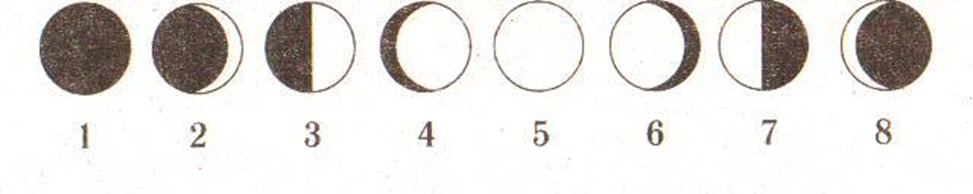
17. What are the numbers under which the full moon and new moon are shown in the picture?
How to determine, being in the northern hemisphere, which aging month
_____________________________________________________________________________
_____________________________________________________________________________
18. Name the iconic places of your city
Answer: _______________________________________________________________________
_____________________________________________________________________________
_____________________________________________________________________________
_____________________________________________________________________________
19. Guess the geographic riddles
A) For a chemist - formula chemical reactions, for a mathematician, numbers and equations, but what for a geographer? ________________________________________________________________
B) What can be called the "hot blood of the Earth"? ___________________________________
C) Pronoun + Scottish horse + pronoun \u003d state in Asia _____________
D) Not the sea, not the land, ships do not float and you cannot go ___________________________
20.
In hot, dry weather, forest fires occur. What should be done to minimize the likelihood of fires?
___________________________________________________________________________________________________________________________________________________________________________________________________________________________________________________________________________________________________________________________________________________________________________________________________________________________________________________________________________________________________________________________________________________________
Answers
Test tour (1 point each):
1 b 9 b
2 b 10 a
3 in 11 a
4 c 12 b
5 in 13 in
6 b 14 c
7 b 15 c
Theoretical tour:
16. Equator - 2 points; desert - 2 points
17. 5, 1. In the northern hemisphere by the month on the left side, mentally substitute a vertical stick. If, when the month and the stick are combined, the letter P is obtained, then the month is growing, and if not, then it is aging (5 points)
18. Free choice of students - 0.5 points each (max -5 points)
19.A) map
B) volcano
C) Japan
D) swamp - 1 point for the correct answer (max - 4 points)
20. Do not throw burning matches or unextinguished cigarette butts on the ground.
Do not make fires during a fire-hazardous period.
Do not burn garbage in the forest.
Do not leave in the forest glass bottles or shards of glass.
Light a fire only in specially designated places.
Before leaving the parking lot, the fire must be completely extinguished - 0.5 points each
for each correct answer (max -3 points)
School stage of the school Olympiad
in geography 8 - 9 grades
in 2009 - 2010
8th grade
1. What letter on the world map represents a point with coordinates 45 ° S. and 17 ° W?
1) A 2) B 3) C 4) D
2. Landforms created by wind activity are most characteristic of the natural zone:
1) Taigi
2) Broadleaf forests
3) Tundra
4) Deserts
3. The category of combustible minerals includes
1) Phosphorites
2) Apatity
3) Peat
4) Asbestos
4. Which statement is true about Australia's topography?
1) The Great Dividing Range is a seismically active area.
2) The mountains run along the west coast of Australia.
3) There are no active volcanoes in Australia.
4) Australia is the highest southern mainland.
5. Which of the listed territories of Eurasia has the highest average annual precipitation?
1) On the Scandinavian Peninsula
2) On the Malacca Peninsula
3) On the western slopes of the Altai mountains
4) On the western slopes of the Alps
6. What statement about the Earth as a planet Solar system right?
1) The Earth is the planet closest to the Sun.
2) The Earth revolves around the Sun in a clockwise direction (as viewed from the North Star).
3) The Earth rotates on its axis from west to east (when viewed from the North Pole).
4) The angle of inclination of the earth's axis to the orbital plane is approximately 23 °.
7. On which of the listed peninsulas is the extreme eastern mainland point of Russia?
1) Kamchatka
2) Taimyr
3) Chukotka
4) Yamal
8. It was 16 o'clock in Norilsk when the plane took off for Moscow. The plane flew for 4 hours. It was 16 o'clock in Moscow when he landed. What time zone is Norilsk in? Write down the answer in numbers.
9. Establish correspondences between subjects Russian Federation and the letters with which they are marked on the map.
SUBJECT RF LOCATION ON MAP
A) Tomsk region 1) A
B) Amur Region 2) C
C) Republic of Buryatia 3) C
4) D
Assignments 10 and 11 are completed using the map below.
10. Determine on the map the distance on the ground in a straight line from point A to the spring.
Answer: _______________ m.
11. Determine the azimuth on the map along which you need to go from point B to the spring.
Answer: ________________ m.
12. Is it possible at night, while at the mill, to observe the fire made in the camp near the spring? Justify your answer.
13. Build a profile of the terrain along the line A - B using a horizontal scale: 1 cm - 100 m and vertical: 1 cm - 5 m. Indicate the position on the profile of the spring with an arrow.
14. Why is salinity in tropical latitudes surface waters The world's oceans are higher (about 36%) than the equatorial ones (about 34%)?
15. What kind negative consequences may have deforestation on slopes Caucasus mountains? State at least two consequences.
16. Why is there a sharp drop in air temperature on the coast of the Gulf of Mexico in winter (up to -10 ° C)?
17.
18. Why in the north is West - Siberian Plain is there permafrost in the tundra zone?
19.
20. Why are karst landforms more widespread in the Cis-Urals than in the Trans-Urals?
Answers
1.
2. 4
3. 3
4. 3
5. 2
6. 3
7. 3
8. 6
9. 243
10. 200 m
11. 270 ˚
12. Being at the mill, it is possible to observe the fire, since the spring is located in the gully and is clearly visible from the hill.
13.
14. The salinity of ocean surface waters depends on the ratio of precipitation and evaporation. In tropical latitudes, with a predominance of downdrafts, the amount of precipitation is less than in equatorial ones, and evaporation is greater.
15. Deforestation leads to a decrease in the soil's ability to retain moisture, to an increase in surface runoff, therefore, in mountainous areas, the destruction of forests on the slopes leads, on the one hand, to an increase in river flooding, causing flooding, and on the other hand, to increased water erosion, the development of landslides, which causes damage agricultural land and settlements.
16. Arctic air masses forming in the north North America, can penetrate to the latitude of the Gulf of Mexico; the relief of the mainland in the central part is flat and they do not encounter obstacles (in the form of mountain ranges) on their way. The Canadian Arctic Archipelago, Greenland, the cold Hudson Bay jutting deep into the land on one side, and the Gulf of Mexico, which is also deep into the land, on the other, create large differences in temperature and pressure between the north and south of the mainland, which, in turn, can cause air movement. masses from north to south.
17. In humid equatorial forests there is a large amount of plant litter; there are favorable conditions for the vital activity of soil microorganisms. However, with a large average annual rainfall and daily rainfall, the soil is washed to a great depth, and nutrients are washed out from it. In addition, hot and humid climates contribute to the fact that organic matter entering the soil is very quickly decomposed and absorbed by plants. Thus, the accumulation of humus does not occur.
18. The north of the West Siberian Plain lies in the arctic and subarctic climatic zones. These climate types are characterized by long and severe winters. Little precipitation falls, the height of the snow cover is low. Therefore, it does not protect the ground from deep freezing. Freezing is also facilitated by strong winds typical for these types of climate.
19. All of these cities are located at approximately the same latitude. The height of the Sun depends on the time of day and the maximum is at noon. At 10 o'clock GMT, noon will be on meridian 30˚ v.d. of all the listed cities, Krasnoyarsk is the farthest from this meridian. Therefore, in this city, the minimum height of the Sun will be observed.
20. Karst landforms are formed if the territory is composed of soluble rocks (gypsum, salt, limestone). For the Cis-Ural foredeep, sedimentary rocks are more typical (many of which dissolve when water interacts). In the Trans-Urals, soluble rocks are less common; hard crystalline rocks prevail. In addition, more precipitation falls in the Cis-Urals than in the Trans-Urals.
From 1 to 7 - 1 point
From 8 to 11 - 2 points
From 12 to 21 - 3 points
Maximum points: 7 + 8 + 30 \u003d 45 points
Grade 9
1.Which of the listed rocks associated with the formation of karst landforms?
1) Granite
2) Basalt
3) Quartzite
4) Limestone
2. What natural resources belong to the category of exhaustible renewable?
1) Mineral
2) Climatic
3) Geothermal
4) Soil
3. What natural area takes largest area on the Indian subcontinent?
1) Humid equatorial forests
2) Savannahs and woodlands
3) Semi-deserts and deserts
4) Forest-steppe and steppe
4. Which parts of Africa have predominant heights of more than 1000 m?
1) North and South
2) Eastern and Western
3) North and West
4) East and South
5. Which statement about the Earth as a planet of the solar system is true?
1) December 22 at the equator the length of the day and night are the same.
2) The angle of inclination of the earth's axis to the orbital plane is 23.5˚ .
3) The earth rotates on its axis from east to west, as viewed from the North Pole.
4) The total surface area of \u200b\u200bthe globe is 820 million square meters. km.
6. Which of the following states have a land border with Russia?
1) Sweden and Moldavia
2) Romania and Tajikistan
3) Poland and Azerbaijan
4) Iran and Turkmenistan
7. Which of the listed peoples is the most numerous in the population of Russia?
1) Kazakhs
2) Ukrainians
3) Armenians
4) Belarusians
8. Which of the following cities in Russia is the largest in terms of population?
1) Izhevsk
2) Samara
3) Tver
4) Vladivostok
9. In what part of the East - European Plain has the least precipitation?
1) Northeastern
2) Northwest
3) Southeast
4) Southwestern
10. Which of the listed peoples belongs to the indigenous peoples of the Far East?
1) Komi
2) Bashkirs
3) Koryaks
4) Evenki
11. Which of the statements contains information about the formation of metamorphic rocks?
1) Fragments of rocks transported by rivers are deposited in depressions and lowlands, then compacted and cemented under the influence of the weight of the overlying layers.
2) Rocks can change their original properties and transform into other types of rocks under the influence of pressure and high temperatures at great depths.
3) If magma reaches the surface of the earth and poured out on it, then it quickly cools down, and rocks consisting of small crystals are formed.
4) Remnants of plants and animals are deposited at the bottom of reservoirs, of which through long time under certain conditions, rocks are formed.
12. Which of the following scientists contributed to the study of soils and created the doctrine of soils and the laws of their distribution?
1) V.I. Vernadsky
2) V. A. Obruchev
3) V.V. Dokuchaev
4) A.E. Fersman
13. What time (including maternity) will it be in Khabarovsk (9th time zone), when in Copenhagen (1st time zone) 12 noon? Write down the answer in numbers.
14. Establish a correspondence between the republic within the Russian Federation and its capital.
REPUBLIC CAPITAL
1) Udmurtia A) Vladikavkaz
2) Kabardino - Balkaria B) Izhevsk
3) Kalmykia B) Elista
D) Nalchik
15. Define the region of Russia according to the short description.
This region ranks second in the Central Region in terms of population density; it is one of the regions of Russia with the largest share of the elderly population in the age structure. There are several large power plants in the region, which were previously focused on local coal, but are now converted to natural gas and imported coal. The basis of the industry is made by chemical enterprises (production mineral fertilizers, products household chemicals, chemical fiber, synthetic rubber). In mechanical engineering, the set of factories of the military - industrial complex stands out. In addition, the region produces equipment for the chemical industry, railway transport, harvesters, and radio engineering products. In the administrative center, there are enterprises for the production of pig iron and ferroalloys; the city has long been famous for its weapons.
Assignments 16 and 17 are completed using the map below.
16. Determine on the map the distance on the terrain in a straight line from point A to point B.
Answer ____________________ m.
17. Determine the azimuth on the map along which you need to go from point A to point B.
Answer ___________________ m.
18. Which side from the field road - to point A or to point B - is it easier to ski?
19. Build a profile of the terrain along the line A - B using a horizontal scale: 1 cm - 100 m and vertical: 1 cm - 10 m. Use the arrow to indicate the position on the profile of the field road.
20. In the subtropical zone, the snow boundary lies at an altitude of 4500 - 5000 m, in the moderate - at an altitude of 2500 - 3500 m, on the Arctic islands - 100 - 150 m. Explain why the height of the snow line changes in the latitudinal direction.
21. What are the changes associated with the widespread use natural gas as a raw material originated in the geography of nitrogen fertilizer production?
22. Drilling of artesian wells has created irrigated land in a drought-stricken area of \u200b\u200bthe country. In the early years, this allowed a sharp increase in land productivity, but soon the yield began to fall sharply. With what it can be connected?
From 1 to 12 - 1 point
From 13 to 17 - 2 points
From 18 to 22 - 3 points
Maximum points: 12 + 10 + 15 \u003d 37 points
For the full version of the Olympiad with answers and figures, see the attached file
SCHOOL STAGE OF THE OLYMPIAD IN GEOGRAPHY 2014-2015.
"Grade 8 answer form"
ANSWER FORM
PART A (test)
PART B
View document content
"Grade 8 assignments"
Department of Education of the City District Administration of Rybinsk
MOU DPO "Information and Educational Center"
School stage All-Russian Olympiad by geography
8th grade.
The work time is 45 minutes. The maximum score is 100.
ATTENTION. The answers are entered into the form!
GOOD LUCK!
PART A(3 points for the answer)
Which country recorded the highest air temperature in the globe?
C) Mexico
D) Saudi Arabia
Mountain glaciers occupy the largest area in the Himalayas. Their further spread is hindered by:
Please enter an incorrect statement:
This natural area with the famous lake located here is called the “dead heart” of the mainland. Among the hot deserts, there is a depression in the relief (12 meters below ocean level), which is filled with water only in summer from rivers and streams with a variable watercourse, sometimes reaching an area of \u200b\u200b15 thousand km2. During the rest of the year, the reservoir dries up, and thick layers of salt lie at its bottom. Sometimes the lake remains dry for several years in a row. Life freezes around. What continent and what lake are we talking about?
In geography class, sixth graders drew up a plan for the schoolyard. On a sheet of paper, its dimensions were 10x15 cm.What scale did the guys use if real size yard - 200x300 m?
Establish what correspondence "mountains - highest point" right:
The largest amount of water vapor can dissolve in air at a temperature:
The Antarctic Circle was first crossed by an expedition led by:
Determine the distance between Dublin (6 ° W) and Minsk (27.5 ° E) along the parallel of 53.5 ° N. (1 ° - 66 km).
PART B
(15 points)
(10 points)
In the northeast of Siberia, after a short spring, a short but relatively warm summer begins. At this time, a reduced pressure is established over the mainland of the country, and over northern seas - higher. Explain this fact.
(20 points)
(10 points)
Indicate continents with the following characteristics: wettest, driest, hottest, coldest, smallest. (5 points)
There is an area on Earth where agriculture is practiced beyond the Arctic Circle in open ground, not in greenhouses. Which countries belong to this area? Why, unlike other regions of the Arctic, is agriculture possible here? (10 points)
View document content
"Grade 8 keys"
8TH GRADE
KEYS
PART A (test)30 points
Classify geographic concepts... Indicate the classification principles: Meridian, altitude, nature conservation, geographic longitude, plain, watershed, waste heap, river feeding, pond, natural zone, phosphorites. (15 points)
For correctly identified groups and each correctly indicated correspondence of a concept to a group - 1 b.
Geographic map - meridian, geographic longitude, relative altitude.
Lithosphere - plains, waste heaps, phosphorites.
Hydrosphere - river feeding, watershed, pond.
Mark (sign) on the contour map:Scandinavian Peninsula, Caribbean Sea, New Zealand, Strait of Mozambique, Tierra del Fuego, Iceland, Alps, Big Barrier reef, Kamchatka Peninsula, Bay of Bengal. (1x10 \u003d 10 points)
In the northeast of Siberia, after a short spring, a short but relatively warm summer begins. At this time, a lower pressure is established on the mainland of the country, and a higher pressure over the northern seas. Explain this fact. (20 points)
Northern water Arctic Ocean cold and the air above it is also cold and therefore heavy. Descending to the surface of the water, it forms high pressure... Dry land heats up faster in summer, warm, light air rises and pressure is low.
What unites the Ob and the Amazon?(2x5 \u003d 10 points)
Both originate from high mountains (Andes and Altai), formed from the confluence of two rivers (Maranyon and Ucayali, Biya and Katun), flow through large lowlands covered with forests and swamps and end with estuaries.
5. Indicate continents with the following characteristics: wettest, driest, hottest, coldest, smallest. (5 points)
6. There is an area on Earth where agriculture in the open field is practiced beyond the Arctic Circle, not in greenhouses. Which countries belong to this area? Why, unlike other regions of the Arctic, is agriculture possible here? (10 points)
Scandinavian Peninsula and part of the Kola Peninsula (Nor., Swedish., Fin., Ross.). The climate is softening warm current average temperature June +10, which allows you to grow potatoes, oats, vegetables.